Kenneth Glad
New machinery and increasingly detailed data are changing how woodland work is organized. Moving experimental systems into routine use remains a challenge.


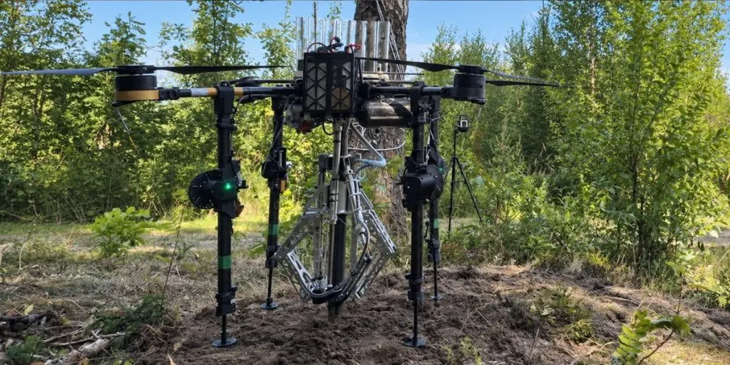
A Norwegian-Danish research team is testing SkyPlanter, a drone system designed to place young trees directly into forest soil. Developed by NIBIO together with the University of Southern Denmark, the technology is still at the prototype stage and has not yet become a commercial planting machine.
NIBIO researchers say the current version can carry seven seedlings at a time, while a commercially practical model would need space for closer to 25. The system also faces physical limitations. Hard soil can be difficult because the aircraft is able to exert only limited force, and a ground-based pilot is still needed to control operations.
The drone lands at a selected planting point, uses its equipment to establish the seedling and then takes off again. The potential scale of the task is considerable: More than 48 million forest seedlings were planted across Norway in 2024.
Interest in lighter planting equipment is partly linked to conditions in Norwegian forestry, where steep terrain and smaller forest holdings can make the use and transport of heavy machinery less practical.


NIBIO said in 2025 that SkyPlanter development was expected to continue into autumn 2026 as researchers explored how the system might eventually move closer to commercial use.
Drones map the forest
Rasmus Astrup, research director at NIBIO, told NRK that efficient planting would probably require several drones working together rather than relying on a single aircraft.
Researchers have also considered greater autonomy, including systems in which several drones could coordinate planting across larger forest areas with less direct human control.
The same technology is being used for more than planting. NIBIO researcher Johannes Rahlf operates sensor-equipped drones that collect measurements such as tree height and diameter.
Artificial intelligence can then process the information to identify individual trees and provide a more detailed picture of forest condition. For forest owners, that kind of data can make it easier to understand what is growing in a particular area and where closer attention may be needed.
Digital records are also being created at ground level. At Glommen Mjøsen Skog in Norway, Anne Guri Kløvstad selects whether she is planting spruce or pine and records each seedling’s GPS position after it has been placed in the soil.
According to NRK, the resulting records can help locate areas affected by rot and support later decisions about which tree species are better suited to particular sites.
Turning these systems from research projects into tools used across the industry remains another challenge. Norges Skogeierforbund says Norway already has considerable expertise in forest data and airborne laser scanning, but relatively few companies connect research, forestry operations and investment.
The organization has therefore called for stronger data infrastructure and more pilot projects where new systems can be tested under practical conditions before they are introduced more widely.
Sources: NRK; NIBIO; Norges Skogeierforbund, University of Southern Denmark